Rest assured, I am still recording videoblog entries, but I'm running into some trouble uploading them in a timely fashion. Day 3 is done and I'm editing day 4, but the hostel here charges for internet access by the megabyte, and after my laptop crashed 80% of the way through uploading day 3's entry, I'm not prepared to retry until I have a more robust connection.
Friday, February 3, 2012

Day 4: Kohukohu to Waipoua Forest
Distance: 58.1k
Distance so far: 244.3k
Speed: 11.5k/h
Runkeeper logs: 1 2
Having previewed the ride the day before, I was a bit intimidated about today. There's a lot of hills, including some quite steep ones, and a gentler but much longer climb up into Waipoua Forest itself. Nothing I can do about them other than tackle them and see how I go, though.
I started early, waking up at 6, and getting on the road by 7, just in time to catch the first ferry of the day. I took the ferry from Kohukohu to Rawene - which I would like to make clear is Not Cheating - then headed for Waipoua. Weather was overcast, with a fine mist falling most of the morning; not enough to make my worry about the electronics. It wasn't cold, though, so I just rode though it. The hills set in immediately, with some fairly low ones between Rawene and Opononi.
The rain abated by the time I made it to Opononi and Omapere, two lovely little waterfront towns. On the opposite side of the harbor are the most incredible giant sand dunes I've ever seen.

I stopped just after Omapere at the "Schooner Cafe" for a tasty and nutritious (second) breakfast of banana pancakes and bacon, as well as my morning coffee. The Schooner Cafe sits just above the foot of the first serious hill of the day, Pakia Hill. Though far from the tallest at only 100m or so high, it's by far the steepest, with a really quite intimidating slope. Freshly fueled with bacon and coffee, though, I surprised myself by managing it just fine.
Fairly rolling country followed, with one more significant climb before the tiny town of Waimamaku.
After Waimamaku, the climb towards Waipoua forest starts. The climb is about 6k long, but with a fairly gentle, consistent slope the whole way. It ascends roughly 400 meters to the summit over that stretch. This proved tough, but not as tough as I thought it would be. I was able to tackle much of it in a gear a few up from my lowest, meaning I made slightly better time of it. Still, 6k is a lot of climbing, so by the time I reached the top, I was glad that was (more or less) it for the day.
Then I got to reap the rewards of all my hard work with a brisk downhill ride into the forest. Waipoua forest is astonishingly beautiful. It's one of the largest remaining tracts of largely untouched native NZ forest, and it goes right up to the road's edge, so you're riding between tall walls of dense vegetation, with ferns, native bushes and trees all competing for space along the roadside, and the occasional Kauri towering over it all.
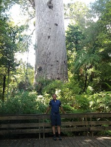
I stopped briefly at Tanae Mahuta, one of NZ's tallest Kauri, for the obligatory photo:
Then it was onwards for the final short leg of the day. This involved a 2k gentle climb, then about 6k of even descent through the heart of the forest. Imagine this: you're on a fairly narrow two lane road. It twists and turns, mostly with broad curves, through an astonishingly verdant native forest, always descending. You're travelling along it at speeds between 30 and 60k/h, sitting about 30 centimeters above the ground. Ferns whip past you every time you take an inside corner. Occasionally, a towering Kauri tree can be seen poking its crest over the top of the rest of the vegetation. That should give you some idea of what the last bit of my fourth day on the road was like.
Distance so far: 244.3k
Speed: 11.5k/h
Runkeeper logs: 1 2
Having previewed the ride the day before, I was a bit intimidated about today. There's a lot of hills, including some quite steep ones, and a gentler but much longer climb up into Waipoua Forest itself. Nothing I can do about them other than tackle them and see how I go, though.
I started early, waking up at 6, and getting on the road by 7, just in time to catch the first ferry of the day. I took the ferry from Kohukohu to Rawene - which I would like to make clear is Not Cheating - then headed for Waipoua. Weather was overcast, with a fine mist falling most of the morning; not enough to make my worry about the electronics. It wasn't cold, though, so I just rode though it. The hills set in immediately, with some fairly low ones between Rawene and Opononi.
The rain abated by the time I made it to Opononi and Omapere, two lovely little waterfront towns. On the opposite side of the harbor are the most incredible giant sand dunes I've ever seen.

I stopped just after Omapere at the "Schooner Cafe" for a tasty and nutritious (second) breakfast of banana pancakes and bacon, as well as my morning coffee. The Schooner Cafe sits just above the foot of the first serious hill of the day, Pakia Hill. Though far from the tallest at only 100m or so high, it's by far the steepest, with a really quite intimidating slope. Freshly fueled with bacon and coffee, though, I surprised myself by managing it just fine.
Fairly rolling country followed, with one more significant climb before the tiny town of Waimamaku.
 |
| Progress is slow in Waimamaku. |
After Waimamaku, the climb towards Waipoua forest starts. The climb is about 6k long, but with a fairly gentle, consistent slope the whole way. It ascends roughly 400 meters to the summit over that stretch. This proved tough, but not as tough as I thought it would be. I was able to tackle much of it in a gear a few up from my lowest, meaning I made slightly better time of it. Still, 6k is a lot of climbing, so by the time I reached the top, I was glad that was (more or less) it for the day.
Then I got to reap the rewards of all my hard work with a brisk downhill ride into the forest. Waipoua forest is astonishingly beautiful. It's one of the largest remaining tracts of largely untouched native NZ forest, and it goes right up to the road's edge, so you're riding between tall walls of dense vegetation, with ferns, native bushes and trees all competing for space along the roadside, and the occasional Kauri towering over it all.
I stopped briefly at Tanae Mahuta, one of NZ's tallest Kauri, for the obligatory photo:
Then it was onwards for the final short leg of the day. This involved a 2k gentle climb, then about 6k of even descent through the heart of the forest. Imagine this: you're on a fairly narrow two lane road. It twists and turns, mostly with broad curves, through an astonishingly verdant native forest, always descending. You're travelling along it at speeds between 30 and 60k/h, sitting about 30 centimeters above the ground. Ferns whip past you every time you take an inside corner. Occasionally, a towering Kauri tree can be seen poking its crest over the top of the rest of the vegetation. That should give you some idea of what the last bit of my fourth day on the road was like.
Thursday, February 2, 2012
Starting day 4
I'm up early, and I'm about to start on day 4. Today's journey has me finishing in Waipoua Forest, at the campsite there, and there's definitely no cellphone signal, and probably no internet access - so don't expect today's update until tomorrow, in all likelihood.
Wednesday, February 1, 2012
Day 3: Kaitaia to Kohukohu
Distance: 76.4k
Distance so far: 186.2k
Speed: 15.0k/h
Runkeeper logs: 1 2 3
My original plan for today was to head east to Whangaroa. From there, I'd follow the east coast, eventually ending up at Whakatane. At the last minute, though, I've decided to change my route, so today had me riding from Kaitaia to Kohukohu, a scenic but tiny town on Hokianga harbor. From there, I'll take the ferry - which I'd like to make clear is Not Cheating - to Rawene, and proceed down the west coast instead, eventually ending up at the thiving metropolis (ha!) of Dargaville. From there, my route converges with the one I planned originally.
Today's route was about 75km according to the guide, with only 3 big hills, all in the first half of the ride. 75km makes it the longest day so far, but since there weren't so many hills, it wouldn't be that bad, I figured. How wrong I was!
I started out a bit before 9, taking the road south out of Kaitaia, then switching to the "Twin Coasts Scenic Route". Scenic it certainly was, starting with fields on either side and hills in the distance, and graduating into native forest as I approached the hills. Traffic was initially very heavy, with no shoulder to speak of, but diminished markedly as soon as I turned onto the road to Kohukohu.
The hills turned out to be at least as difficult as advertised, first merely tedious, but graduating into frustrating, then exhausting. The hill just before Broadwood, my halfway-plus-a-bit point, was absolutely brutal, requiring me to stop 2 or 3 times on the way up for a breather.
I got into Broadwood at about noon. Broadwood proved to be a tiny town, with a general store and public toilets and not much else. I paused for a snack and a drink, then continued on, already pretty exhausted - but I knew I was done with the first two hills, and on the top of the third one, so the rest ought to be relatively easy.
The rest of the route, despite my tiredness, proved to be a lot of fun. The road wound about through the hills, but seemed to be constructed pretty much along a contour line, neither going up nor down a great deal, which made for a fun ride. Once we reached the end of the hills, I was treated to an enjoyable high-speed descent, and a short while later, I was in Kohukohu, getting there around 2PM.
Kohukohu is likewise a fairly tiny town, featuring a general store, a couple of cafes, and a post shop. I had a coffee and a light (late) lunch before continuing on to my accommodation for the night, the Treehouse Backpackers' Lodge. The treehouse is a really nice little backpackers' hostel, with a couple of rooms in the main accommodation block, and more in small cabins scattered around a property that's dense in native bush, with well maintained pathways through it - a really nice setting for some downtime. The proprietors are friendly and helpful, and although there aren't many others staying at the moment, the atmosphere is pleasant and social.
Given the amount of cycling I did today and the nature of the next leg - a long hard climb into Waipoua forest - as well as how pleasant things are here, I've decided to take the next day off to rest, so I won't be riding tomorrow.
Distance so far: 186.2k
Speed: 15.0k/h
Runkeeper logs: 1 2 3
My original plan for today was to head east to Whangaroa. From there, I'd follow the east coast, eventually ending up at Whakatane. At the last minute, though, I've decided to change my route, so today had me riding from Kaitaia to Kohukohu, a scenic but tiny town on Hokianga harbor. From there, I'll take the ferry - which I'd like to make clear is Not Cheating - to Rawene, and proceed down the west coast instead, eventually ending up at the thiving metropolis (ha!) of Dargaville. From there, my route converges with the one I planned originally.
Today's route was about 75km according to the guide, with only 3 big hills, all in the first half of the ride. 75km makes it the longest day so far, but since there weren't so many hills, it wouldn't be that bad, I figured. How wrong I was!
I started out a bit before 9, taking the road south out of Kaitaia, then switching to the "Twin Coasts Scenic Route". Scenic it certainly was, starting with fields on either side and hills in the distance, and graduating into native forest as I approached the hills. Traffic was initially very heavy, with no shoulder to speak of, but diminished markedly as soon as I turned onto the road to Kohukohu.
 |
| An interesting sculpture on the way to Broadwood, slightly modified |
 |
| A disused sheep run, overgrown with ferns. |
The hills turned out to be at least as difficult as advertised, first merely tedious, but graduating into frustrating, then exhausting. The hill just before Broadwood, my halfway-plus-a-bit point, was absolutely brutal, requiring me to stop 2 or 3 times on the way up for a breather.
I got into Broadwood at about noon. Broadwood proved to be a tiny town, with a general store and public toilets and not much else. I paused for a snack and a drink, then continued on, already pretty exhausted - but I knew I was done with the first two hills, and on the top of the third one, so the rest ought to be relatively easy.
The rest of the route, despite my tiredness, proved to be a lot of fun. The road wound about through the hills, but seemed to be constructed pretty much along a contour line, neither going up nor down a great deal, which made for a fun ride. Once we reached the end of the hills, I was treated to an enjoyable high-speed descent, and a short while later, I was in Kohukohu, getting there around 2PM.
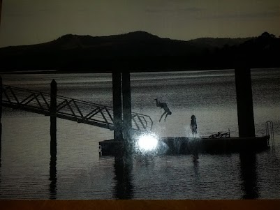
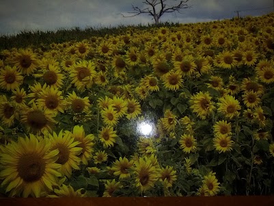
A couple of the postcards featuring photos by local artists (hint hint)
Kohukohu is likewise a fairly tiny town, featuring a general store, a couple of cafes, and a post shop. I had a coffee and a light (late) lunch before continuing on to my accommodation for the night, the Treehouse Backpackers' Lodge. The treehouse is a really nice little backpackers' hostel, with a couple of rooms in the main accommodation block, and more in small cabins scattered around a property that's dense in native bush, with well maintained pathways through it - a really nice setting for some downtime. The proprietors are friendly and helpful, and although there aren't many others staying at the moment, the atmosphere is pleasant and social.
Given the amount of cycling I did today and the nature of the next leg - a long hard climb into Waipoua forest - as well as how pleasant things are here, I've decided to take the next day off to rest, so I won't be riding tomorrow.
Tuesday, January 31, 2012
Change of plans
Last minute change of plans: I'm headed for Kohukohu instead, following the scenic route south of Kaitaia. It's longer than I'd planned for the day - 70km - but there aren't many hills.
I'm on the road now, so you can use the links on the right to follow me if you care to track my progress.
I'm on the road now, so you can use the links on the right to follow me if you care to track my progress.
Postcards update
Okay, so I've got the nitty-gritty behind the postcard scheme (is 'scheme' a bad word? maybe 'program'?) set up. Go here for all the details and instructions. Act in the next half hour and I might be able to send you something from Kaitaia!
As a reminder, here's the elevator pitch: Contribute $25 or more towards the Ride to Conquer Cancer, which benefits the Chris O'Brien Lighthouse, and I will send you a postcard from a scenic town in New Zealand, to anywhere in the world. You can nominate the town you'd like me to send it from - anywhere on my planned route - and specify the message you'd like on it.
As a reminder, here's the elevator pitch: Contribute $25 or more towards the Ride to Conquer Cancer, which benefits the Chris O'Brien Lighthouse, and I will send you a postcard from a scenic town in New Zealand, to anywhere in the world. You can nominate the town you'd like me to send it from - anywhere on my planned route - and specify the message you'd like on it.
Subscribe to:
Posts (Atom)